We need your input! Please take a moment to fill out our website satisfaction survey by clicking here.

Kate Hagermann
Climate Adaptation and Resilience Planner

1400 Fifth Avenue
San Rafael, CA 94901

Sea Level Rise Collaborative

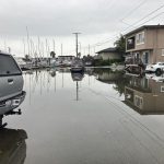
The Canal Community Resilience Planning Project is a collaborative effort exploring the feasibility of different adaptation actions to address flooding risks.

The project partners, including The Canal Alliance, the County of Marin, the Multicultural Center of Marin, and researchers at the University of California Berkeley, are working together to understand the hazards facing our community, prioritize actions, build capacity, and provide STEM educational opportunities for students.

The project includes the entire physical area around the Canal (known as an “operational landscape unit”). However, we’re prioritizing engagement in the Canal neighborhood, which is the most vulnerable to sea level rise, to ensure equity in the process and outcomes.

Over the next year, we plan to work alongside residents to co-create ideas to improve our resilience. There’s no right answer, so this project will be a conversation with our community, especially those who are disproportionately vulnerable.

Do you have ideas? Want to stay in the loop? Please take the short survey below to add your voice to the project!

Learn more about the project

To learn more about the project, please watch our quick video summary and take our short survey.

If you want to dive in, you can see the complete work plan for the Coastal Conservancy grant here and the work plan for the Office of Planning and Research grant here.

What’s Been Done So Far 

The City has worked for years with others in the Bay Area to support a future that is more resilient to the effects of climate change and disasters.

The City is a member of the Bay Area Climate Adaptation Network, the Marin Climate and Energy Partnership, the BayWAVE Executive Steering Committee, the Marin Wildfire JPA, Drawdown: Marin, and other collaborative efforts.  

More about these efforts, studies, and projects is below.  

Building off the foundation of the BayWAVE Vulnerability Assessment and more current resources, City staff prepared the Flood Risk & Sea Level Rise Adaptation  Report, which was incorporated into General Plan 2040. This report “set the stage” by providing guidance on how to develop an adaptation plan. The report suggested the following: 

  1. Establish clear objectives through a community-based process 
  2. Utilize Adaptation Land Use Planning – Guidance for Marin County Local Governments 
  3. Identify policy and regulatory measures 
  4. Identify the appropriate adaptation tools and strategies 
  5. Identify financing measures and funding sources for implementation 

In 2019, the City Council adopted the San Rafael Climate Action Plan 2030 (CCAP 2030). CCAP 2030 primarily focuses on reducing greenhouse gas emissions, the pollution that causes climate change. The plan also acknowledges the need to adapt to the effects in two programs:  

  • Sea Level Rise – Prepare and adapt to a rising sea level (Program SA-C4), and  
  • Climate Change Adaptation – Prepare for and respond to the expected impacts of climate change (Program SA-C5). 

The San Rafael Wildfire Prevention and Protection Action Plan outlines goals to proactively address the growing risks of wildfires. The primary objectives include:

  • Ordinance changes to mitigate wildfire risk
  • Additional staffing, funds, and resources to address hazards & expand public education
  • Expanded and new fuel reduction and preparedness efforts

Improving and increasing vegetation management plans

This project was part of a year-long collaborative design challenge that brought residents, public officials and other experts together to develop innovative solutions to strengthen the Bay Area’s resilience to sea level rise, storms, flooding, and earthquakes.

The Elevate San Rafael project envisioned a new future for the San Rafael waterfront that not only physically elevated infrastructure and development but also raises the quality of life and social connection for everyone. Design solutions addressed near-term needs directly and offered a long-term strategy for large-scale resilience. The proposal framed necessary policy and finance mechanisms to guide change in an equitable way.

This white paper was developed by Paul Jensen with assistance from a Sustainability Intern and the Department of Public Works. The intent was to catalog the studies and resources conducted to date that could serve as a resource for adaptation planning efforts related to sea level rise and flood impacts. It concludes next steps for the City, including preparing a sea level vulnerability assessment. It also included two appendices: A) San Rafael Levees and Shorelines, and B) San Rafael Possible Opportunity Areas for Adaptation.

Link: https://www.cityofsanrafael.org/documents/sea-level-rise-white-paper/

Local governments must adopt a Local Hazard Mitigation Plan in order to be eligible to apply for federal funding pre and post disaster. The San Rafael plan also includes a wealth of analysis about local risks and identifies mitigation strategies to reduce the vulnerability to hazards such as wildfire, flooding, storms and erosion, drought, and heat. It includes sea level rise impacts using assessments by Cal-Adapt and BayWAVE.

Link: https://storage.googleapis.com/proudcity/sanrafaelca/uploads/2018/01/City-of-San-Rafael-LHMP-Complete.pdf

In 2017, the County of Marin, in partnership with local jurisdictions, developed a sea level rise vulnerability assessment for the eastern Marin shoreline from the Golden Gate Bridge to the county line north of Novato. BayWAVE aimed to increase awareness and preparation for sea level rise impacts. The assessment catalogs impacts across six different sea level rise scenarios. The best available science was used to complete the report. It presents asset profiles describing parcels and buildings, transportation networks, utilities, natural resources, recreational assets, emergency services, and cultural resources. It also includes municipal profiles.

Link: https://www.marincounty.org/main/marin-sea-level-rise/baywave/vulnerability-assessment

On-going & Completed Adaptation Projects

San Francisco Bay National Estuary Research Reserve, County of Marin

North San Pedro Road running along the shoreline of China Camp State Park in San Rafael is an important transportation corridor that routinely floods during king tides and winter storms. An ongoing community stakeholder process formulated adaptation goals and continues to evaluate adaptation options. Project goals included maintaining the functionality of and access to China Camp recreational resources; protecting and enhancing natural resources, especially marsh habitats; and maintaining the roadway for commuting, evacuation, and emergency response under sea level rise scenarios. More info.

County of Marin

The McInnis Marsh project proposes to restore subtidal and intertidal habitat at a 180-acre area of diked wetlands within McInnis Park. It is designed to protect park and sanitary district facilities, as well as important ecosystems and to improve habitats for threatened and endangered species. More info.

Marin Audubon Society & City of San Rafael

Building on the preliminary design produced by Environmental Science Associates (ESA) with a grant from the Marin Community Foundation, this phase of the Tiscornia Marsh Restoration and Sea Level Rise Adaptation Project will advance the design for restoring marsh habitat and improving the levee, connecting with community, improving a public trail, and completing environmental review.  The project design will include restoring an eroded section of the marsh, opening the diked marsh to tidal action, stabilizing and improving a section of degraded levee to increase flood protection for the community and providing transition zone habitat for wildlife and flood control. Through this project Tiscornia Marsh would be restored to its former extents by beneficially reusing dredged material from local sources.

The Tiscornia Marsh site covers 20 acres of tidal marsh and bay lands located north and outboard of East Canal Street. The property, partially owned by Marin Audubon Society, is adjacent to Pickleweed Park.

The City is the Lead Agency for the Environmental Impact Report. Click here for more info on this process. More visuals and videos can be found on this website hosted by Marin Audubon Society and the Multicultural Center of Marin.

California State Coastal Conservancy 

Beginning in 2012, the California State Coastal Conservancy advanced San Francisco Bay restoration efforts with a project to analyze subtidal restoration techniques and restore critical eelgrass and oyster habitat, while learning more about the potential physical benefits of biological reefs along the shoreline. A pilot project was conducted in San Rafael Bay and along the Hayward shoreline. The project tested planting and placement of eelgrass units with various oyster substrate units to compare growth rates, densities and recruitment. Findings from the pilot project have been used to inform subsequent projects.

How can I get updates?

To stay updated on the project, sign up for our newsletter below.

Subscribe

* indicates required

How can I get involved?

There are many opportunities to get involved. Sign up to our newsletter  or contact us via email at kate.hagemann@cityofsanrafael.org!

The project has been generously supported by the Marin Community Foundation, California State Coastal Conservancy, and the Governor's Office of Planning and Research.  Project Partner Logos

Close window